
Someone far above me on the cloud-shrouded mountain yells, “Rock!” and a few seconds later a rock the size of a basketball comes whizzing past me off to my right. It makes a whooshing sound while in the air, then bounces its way down the steep rock field below me, a bevy of smaller rocks following in its wake. Then the quiet—except for the steady in-and-out gasping of my breath as I climb—returns to the mountain.
I’m climbing Mount Ngauruhoe (Nah-ooh-roo-hoe-ee) in Tongariro National Park on Christmas Day. My wife, Rebecca, has to work. I’ll send her a picture if I make it to the top.

Mount Ngauruhoe (1)
If you had to pick a volcanic mountain that looked like a volcano, it would be Ngauruhoe. It is the quintessential volcano. It has steep (up to 45 degrees) flanks rising to a central cone. You can see it from much of the central portion of the North Island of New Zealand, although often its summit remains shrouded in cloud.

View of Mount Ngaurohoe as seen from nearby Mount Ruapehu
If you’ve read my previous blogs or know something of New Zealand outdoor adventure, you’ll know the Tongariro Alpine Crossing is a famed, 19-km (12 mile) day-long trek across some of the most spectacular volcanic landscape in the world. Tourists from all over the world include this epic trek in their New Zealand itinerary. Almost everyone starts at the Magatepopo trailhead—it’s slightly more downhill if you go in that direction—and end at the Ketetahi trailhead.
But about a third of the way across the crossing, if you go in the usual direction, is a turnoff to climb Mount Ngaurohoe. Markedly few of the multitudes take it. A sign says “three hour return” meaning in New Zealand parlance that the climb is estimated to take three hours round trip.

Mount Ngauruhoe is 2,291 meters (7,516 feet) high, and the summit is roughly 600 meters (almost 2000 feet) above the turnoff. The weather is notoriously changeable and one is advised to be well-prepared.

Start of trek upward – the summit is somewhere up in the clouds.
Aside from adding considerable time and distance to an already long day if you plan to do the entire crossing, the climb up Ngauruhoe is also fairly steep and there is no real trail. The first few hundred yards are relatively flat and marked with blue poles at regular intervals, and then you are on your own, or follow routes that others have taken up the mountain. The steep, treeless slope consists of volcanic rock of various sizes. Some of it is like climbing uphill through sand; you take two steps forward and slide one step back. Other areas consist of scrambling up over various-sized rocks, some of which are particularly easy to knock loose. In other areas, you almost crawl upward using both your hands and feet. About a third of the way up, off to the left, is a band of more-solidly-fixed, larger rocks. By keeping to the edge of this, it is easier to drag yourself upward, clinging to the rock for support.
Looking down—I’ve reached the band of rocks.
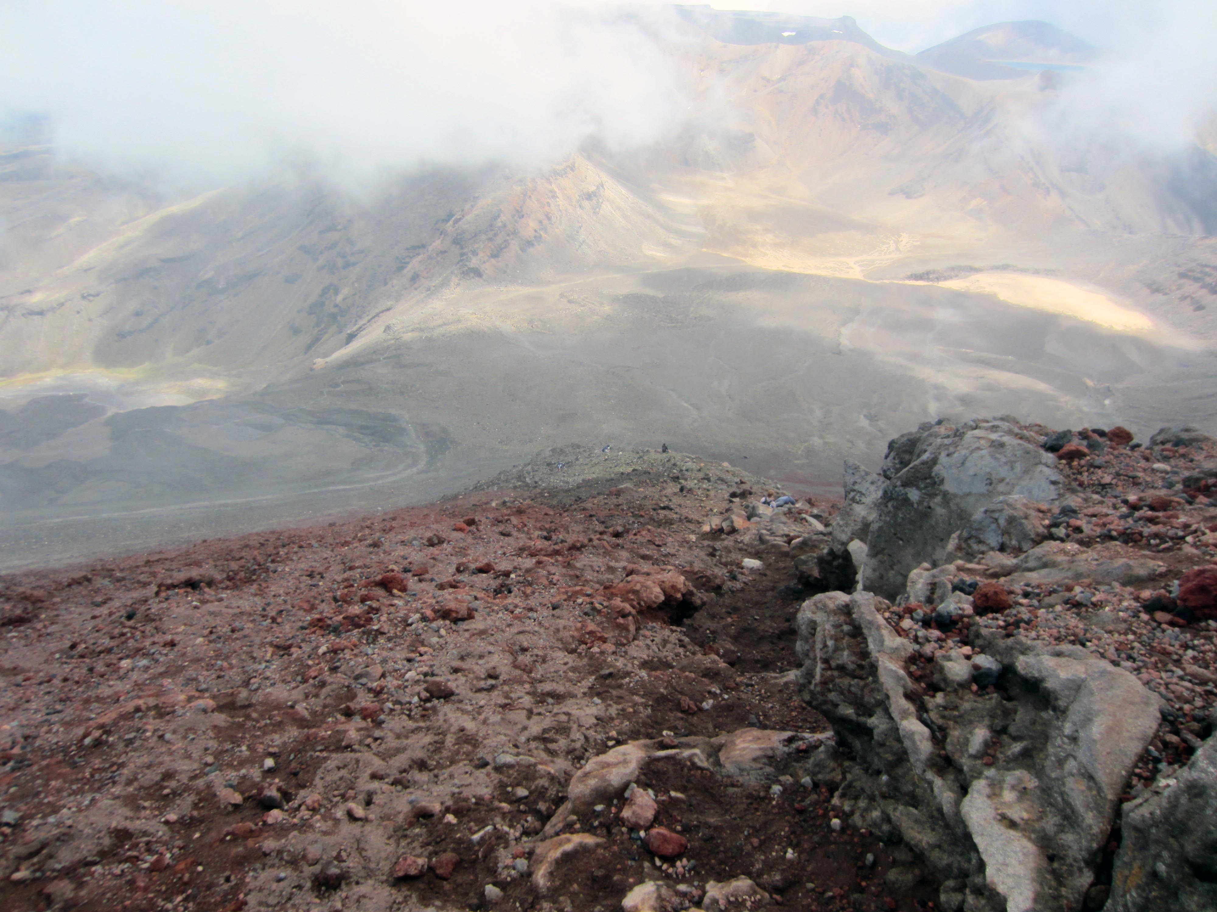
 At least on the day I was there, clouds were constantly roiling around both above and below me. As I climbed upward, at times I could see much of the entire Tongariro Alpine Crossing spread below me. Then it would become smothered in cloud and disappear. Looking upward, I could see a band of yellowish rock, presumably near the top, and a few intrepid climbers far above me. Then the entire scene would disappear and I would be walking steeply uphill through dense cloud.

Other climbers in the cloud.

The final few hundred yards were a particularly dastardly section of predominantly fist-sized rock marbles; take a step and slide back down to where your foot started. If it’s any consolation, the reality is that all these different-sized and different-colored rocks that you climb over when ascending Ngauruhoe are remnants of various types of volcanic activity that occurred at various different times over the last century of so. Finally, two hours after starting the ascent (I’d like to pretend I did the climb in some record time but I didn’t), I peered over the edge of the crater itself—a huge dark, jagged pit with patches of snow in the bottom. Spectacular. Off to one side, a small volcanic vent, a fumarole, puffed volcanic vapors.

The central crater at the top.

View from top.
From the top, on this particular day, because of the clouds I couldn’t see much of anything in any direction. After resting and taking some pictures, I headed back down, which was easier but still time-consuming. As an aside, once you get back to the Ngaurahoe trail junction, you have the entire Tongariro Alpine Crossing to yourself, since it is likely to now be afternoon, and most people start the trek in the early morning. I hiked back to the Mangatepopo trailhead seeing almost no one—oh, there were some crazy Italians jabbering away getting a late start at about two in the afternoon. The whole trip, taking my time, took me about 7 ½ hours and was 19 km in length, and was certainly a memorable experience. It is one of those mountains that once you are finished, you are certainly glad, and I must say proud, to have done it. Did I like the hike itself? I have to admit it is a bit of a slog, and not the type thing you want to do numerous times. But epic and memorable—yes!
Now that I am safely down, I can say something about the volcanic activity of Mount Ngauruhoe. The youngest of three volcanoes in the area, Ngauruhoe’s cone is felt to be only about 2,500 years old. It has erupted forty-five times in the last century, the most recent time being in 1975. Currently, it is listed as being quiescent.

Eruption of Mount Ngauruhoe in 1975 (2).

Another view of Ngauruhoe eruption in 1975 showing pyroclastic flow down sides (3).
The other claim to fame for Mount Ngauruhoe is that it was both the inspiration and was used in a digitally altered form as Mount Doom in The Lord of the Rings films. As I’m sure you know, both The Lord of the Rings and The Hobbit films were filmed entirely in New Zealand.
Mount Doom in the movies is the location where the One Ring was forged by the Dark Lord Sauron, and the only place where it can be destroyed. Frodo, the intrepid hobbit, must travel to Mount Doom in Mordor to cast the ring into its volcanic abyss.
Because the summit of Mount Ngauruhoe is deemed sacred by the local Maori and they did not wish it to be filmed, Ngaurahoe was digitally altered for its use in the films.
What can I say? Climbing an epic volcanic mountain, and reliving a part of The Lord of the Rings—that is New Zealand!
Update: On December 27th, two days after I climbed Ngauruhoe, a climber was struck by a boulder and had to be evacuated from the mountain by helicopter.
All photos by the author except as noted:
1)Monday Escape: Mount Ngauruhoe (Mount Doom), New Zealand | Backpackingmatt.com
www.backpackingmatt.com1024 × 768Search by image
2)http://www.aucklandmuseum.com/whats-on/exhibitions/volcanoes/volcanic-forces/what-goes-down…/twisting-tectonic-plates
3)http://www.doc.govt.nz/parks-and-recreation/places-to-go/central-north-island/places/tongariro-national-park/about-tongariro-national-park/central-north-island-volcanoes/

Did you throw something in the volcano ….just to be on the safe side ???
Was going to throw your daughter in as an offering, but the volcano didn’t want her.